Port Campbell Town Centre Project
Consultation has concluded
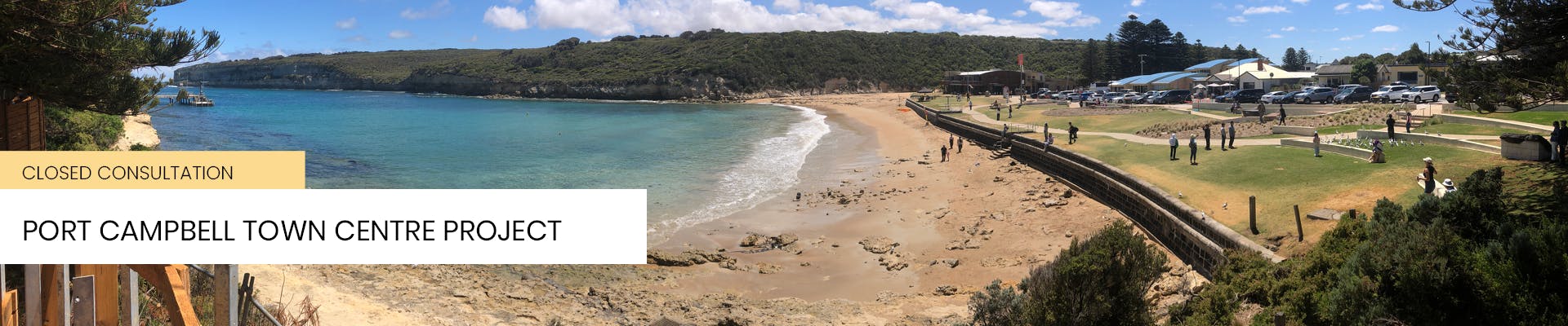
The Port Campbell Town Centre Revitalisation Project is the largest infrastructure project ever undertaken by Corangamite Shire, with a budget of $15.6 million. This project aimed to enhance the functionality and amenity of Port Campbell’s town centre, making it more resilient and attractive, especially during peak tourism seasons.
Key Features of the Project:
- Timber Decking Lookout and Picnic Areas: Under the Norfolk Pines, providing scenic views and recreational spaces.
- Wider Main Road: Designed to accommodate professional fishermen.
- 90-Degree Parking: Retained to ensure ample parking space.
- Al Fresco Dining: Enhanced dining experiences on the foreshore.
- New Street Furniture and Bike Racks: Improving the town's infrastructure.
- New Lawn Areas, Garden Beds, and Trees: Enhancing the town’s green spaces.
- Integrated Art: By Vicki Couzens, adding cultural value.
- Foreshore Amphitheatre: For community events and gatherings.
- Bus Parking: Moved to Lord Street, opposite the tennis courts.
- Additional Car Parks: To accommodate more visitors.
Project Timeline:
- Initial Works: Started in August 2023, focusing on site preparation, surveys, and infrastructure removal.
- Major Construction: Commence in winter 2024 and was completed by April 2025.
The project was funded jointly by the Corangamite Shire Council, the State Government, and the Federal Government
Consultation has concluded
-
Survey Results - Top Roundabout
Share Survey Results - Top Roundabout on Facebook Share Survey Results - Top Roundabout on X (formerly Twitter) Share Survey Results - Top Roundabout on Linkedin Email Survey Results - Top Roundabout linkResults:
Thanks to all who provided feedback.
It was line-ball with 14 people voting it should be converted so all traffic goes down Morris Street and Cairns Street is for local traffic zone, versus 13 against.
The department of Transport is now advising us how to best keep unwanted buses and tourist vehicles on the Great Ocean Road and off local streets.
You may have noticed that works have not yet started at the top roundabout on Morris Street and Great Ocean Road.
These works were part of the 2022 Works Package.
The original plan was to remove the roundabout and modify the intersection to prevent buses continuing straight ahead and then down the Cairns Street hill into town. The modifications would also encourage all incoming traffic to continue down Morris Street.
However, the price quoted for the roundabout removal was too high, forcing us to look at other ways to achieve the same outcome.
The latest advice from the Department of Transport is to keep the roundabout and make the Old Ocean Road ‘exit only’. (See diagram below).
This will channel all incoming traffic down Morris Street and create a ‘local traffic only’ feel at the top of Cairns Street.
We need to know what impacted residents and the wider community think.

If you do not support the ‘exit only’ option, the alternative will be slight modifications to the roundabout to prevent only buses and larger vehicles from continuing straight.
Feedback has now closed, thanks to all those who submitted!
Consultation has concluded
-
Survey Results - Parking
Share Survey Results - Parking on Facebook Share Survey Results - Parking on X (formerly Twitter) Share Survey Results - Parking on Linkedin Email Survey Results - Parking linkThank you to those who completed the survey in September 2023 on preferred type of parking in front of the General Store.
Of the 99 responses we received:
Options Advantages Disadvantages  11 selected option one - current design
 Maintain existing proposed parallel parking with improved parking management
- Parking managed by signs
- Recommended 15 minute time limit to all spaces within 40 metres of General Store
Number of implemented car parks: 3
Total number of parking spaces within 40 metres of General Store: 22
- Maintains the landscape strip along the edge of the street
- Maintains a generous and continuous pedestrian space along the edge of the parking strip
- Safer parking environment - avoiding the needs for drivers to reverse into a shared zone
- Maintains a consistent approach to parking along the entire street reinforcing the design intent of a shared street space
- Light fitting retained in landscape
- Services in landscape strip easy to access
- Disabled parking space retained near general store
- Short term parking will allow spaces for residents and visitors close to the existing General Store/Post Office
- Allows for access to 21 Lord Street
- May require some occasional enforcement for the time limits to be most effective
- Requires residents to walk up to 40 metres (30 seconds) to access store
 11 selected option two - alternative option one
Reconfigure parallel parking to provide five managed parking spaces
- Through reorganising, four 30 degree angle parking spaces could be provided of 5 metres long and 2.6 metres wide
- Parking use would be managed by signs. Recommended 15 minute time limits
Number of implemented car parks: 5
Total number of parking spaces within 40 metres of General Store: 24
- Two additional parking spaces provided
- Short term parking will allow spaces for residents close to the existing General Store/Post Office
- 30 degree parking is easier to enter
- 2.3 metre wide footpath can be retained providing adequate space for pedestrians
- The parking spaces can be increased in size (marginally) to provide a little more flexibility
- Minimal conflict between the parking spaces and the planter box
- Angled parking is inconsistent with the vision for a 'shared pedestrian space'
- Landscape strip along street edge removed
- Size of planter reduced
- Adjoining lots will need to be exactly aligned with finished adjoining footpath levels
- Drivers need to reverse into a shared space which contributes to a less safe environment
- The parking bays will require wheel stops. These will become a potential trip hazard for pedestrians and associated risk for Council in the future
- Removes one accessible parking space for people with a disability
- If the General Store or Post Office move in the future, it is nearly impossible to retro-fit the parking bays back to their preferred orientation
- May raise a fairness/equity issue with traders - why does the General Store get special treatment and other traders don't?
- No access to 21 Lord Street
- Light pole located in footpath
- Services will be located below paving
- May require some occasional enforcement
 77 selected option three - alternative option two - Preferred design
Delete planter and provide seven managed parking spaces
- Through removal of the planter, seven 30 degree angle parking spaces of 5 metres long and 2.6 metres wide could be provided
- Parking use would be managed by signs. Recommended 15 minute time limit
Number of implemented car parks: 7
Total number of parking spaces within 40 metres of General Store: 26
- Four additional parking spaces provided
- Short term parking will allow spaces for residents close to the existing General Store/Post Office
- 30 degree parking is easier to enter
- 2.3 metre wide footpath can be retained providing adequate space for pedestrians
- The parking spaces can be increased in size (marginally) to provide a little more flexibility (although this will reduce the number of additional spaces)
- Angled parking is inconsistent with the vision for a 'shared pedestrian space'
- Landscape strip along street edge removed
- Removes planter, street tree and rain garden
- Adjoining lots will need to be exactly aligned with finished adjoining footpath levels
- Drivers need to reverse into a shared space which contributes to a less safe environment
- The parking bays will require wheel stops. These will become a potential trip hazard for pedestrians and associated risk for Council in the future
- Removes one accessible parking space for people with a disability
- If the General Store or Post Office move in the future, it is nearly impossible to retro-fit the parking bays back to their preferred orientation
- May raise a fairness/equity issue with traders - why does the General Store get special treatment and other traders don't?
- No access to 21 Lord Street
- Light pole located in footpath
- Services will be located below paving
- May require some occasional enforcement
What happens next?
- We have asked Project Architects Hanson to revise detailed plans to reflect what the community wants - Option 3 with more car parks out front of the General Store
- Please note, the nearest accessible park for Option 3 will be out front of REAL
- We are currently seeking quotes for footpath works and traffic calming measures in Morris Street. These works will take place outside of holiday season
-
We will advertise for Tenders for the 2023 Works Package (focusing on Lord Street and Cairns Street) in the next few weeks.
These works include:- Better linkages between existing and new attractions (12 Apostles Trail and suspension bridge)
- Pedestrianisation of town centre including major road upgrades
- Feature pavements, stone and timber seating, phone charging stations and street furniture upgrades
- Decking under Norfolk Island pines
- Increased accessibility to both the foreshore and businesses
- New parking and walking options
- New bus parking area
- Integrated artworks by Dr Vicki Couzens
Consultation has concluded